


CENTREVILLE 12 Voting District, St. Clair County, Illinois
About
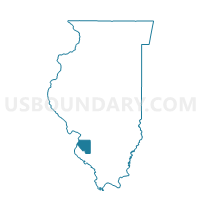
Outline

Summary
| Unique Area Identifier | 574239 |
| Name | CENTREVILLE 12 Voting District |
| County | St. Clair County |
| State | Illinois |
| Area (square miles) | 1.50 |
| Land Area (square miles) | 1.45 |
| Water Area (square miles) | 0.05 |
| % of Land Area | 96.49 |
| % of Water Area | 3.51 |
| Latitude of the Internal Point | 38.58444800 |
| Longtitude of the Internal Point | -90.11176600 |
Maps


Graphs
Select a template below for downloading or customizing gragh for CENTREVILLE 12 Voting District, St. Clair County, Illinois


Neighbors
Neighoring Voting District (by Name) Neighboring Voting District on the Map
- CENTREVILLE 1 Voting District, St. Clair County, IL
- CENTREVILLE 10 Voting District, St. Clair County, IL
- CENTREVILLE 11 Voting District, St. Clair County, IL
- CENTREVILLE 14 Voting District, St. Clair County, IL
- CENTREVILLE 27 Voting District, St. Clair County, IL
- CENTREVILLE 3 Voting District, St. Clair County, IL
- CENTREVILLE 6 Voting District, St. Clair County, IL
- CENTREVILLE 7 Voting District, St. Clair County, IL
- EAST ST. LOUIS 13 Voting District, St. Clair County, IL
- EAST ST. LOUIS 14 Voting District, St. Clair County, IL
- EAST ST. LOUIS 19 Voting District, St. Clair County, IL
- EAST ST. LOUIS 31 Voting District, St. Clair County, IL
Top 10 Neighboring County Subdivision (by Population) Neighboring County Subdivision on the Map
- East St. Louis township, St. Clair County, IL (27,006)
- Centreville township, St. Clair County, IL (25,386)
Top 10 Neighboring Place (by Population) Neighboring Place on the Map
Top 10 Neighboring Unified School District (by Population) Neighboring Unified School District on the Map
- East St. Louis School District 189, IL (38,523)
- Cahokia Community Unit School District 187, IL (19,392)
Top 10 Neighboring State Legislative District Lower Chamber (by Population) Neighboring State Legislative District Lower Chamber on the Map
Top 10 Neighboring State Legislative District Upper Chamber (by Population) Neighboring State Legislative District Upper Chamber on the Map
Top 10 Neighboring 111th Congressional District (by Population) Neighboring 111th Congressional District on the Map
Top 10 Neighboring Census Tract (by Population) Neighboring Census Tract on the Map
- Census Tract 5012, St. Clair County, IL (3,464)
- Census Tract 5028, St. Clair County, IL (2,713)
- Census Tract 5029, St. Clair County, IL (2,085)
- Census Tract 5011, St. Clair County, IL (1,777)
- Census Tract 5025, St. Clair County, IL (1,272)
- Census Tract 5027, St. Clair County, IL (1,251)